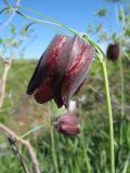
Верхушка побега с цветком. Западный Казахстан (азиатская сторона), окр. оз. Шалкар. 8 мая 2014 г.
Vladimir Kolbintsev © 2014
The marker on the map does not indicate the exact coordinates of the plant or lichen.
The marker does only indicate the conditional center of the terrain ("geographic point") where the photo was taken.
Open mapSee also:
Discussion (4)
All photos of taxon (128)
Code of link to photo
| Create: | HTML or BBCode with preview |
| Code for linking on the web: | |
| This is how it will look: |  Fritillaria ruthenica on the site «Plantarium» |
Text to cite the page
Колбинцев В. 2014. Изображение Fritillaria ruthenica Wikstr. // Плантариум. Растения и лишайники России и сопредельных стран: открытый онлайн атлас и определитель растений. [Электронный ресурс] URL: https://www.plantarium.ru/page/image/id/252599.html (дата обращения: 24.02.2025).
Kolbintsev V. 2014. Image of Fritillaria ruthenica Wikstr. // Plantarium. Plants and lichens of Russia and neighboring countries: open online galleries and plant identification guide. URL: https://www.plantarium.ru/lang/en/page/image/id/252599.html (accessed on 24 Feb 2025).
Views: 995Discussion
| Dmitry Oreshkin | Из подписи:
Западный Казахстан (азиатская сторона) |
| Vladislav Grigorenko | левобережье р. Урал? |
| Vladimir Kolbintsev | Западно-Казахстанская область географически делится на азиатскую (бухарскую) и европейскую (самарскую) стороны с разделом по реке Урал. |
| Dmitry Oreshkin | Может обозначить это так, как предложил Владислав? Особенности географического (кстати, какого? Физико-? Ботанико-?) районирования этой территории знают далеко не все, а вот реку Урал найти просто. |