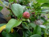
Плод и лист. Приморье, окр. г. Находка, бухта Тунгус, на скалах. 18.06.2016.
Наталья Суровцева © 2016
The marker on the map does not indicate the exact coordinates of the plant or lichen.
The marker does only indicate the conditional center of the terrain ("geographic point") where the photo was taken.
Open mapSee also:
Discussion (3)
All photos of taxon (85)
Code of link to photo
| Create: | HTML or BBCode with preview or HTML or BBCode with image compressed to a given width |
| Code for linking on the web: | |
| This is how it will look: |  Malus mandshurica on the site «Plantarium» |
Text to cite the page
Суровцева Н.В. 2016. Изображение Malus mandshurica (Maxim.) Kom. // Плантариум. Растения и лишайники России и сопредельных стран: открытый онлайн атлас и определитель растений. [Электронный ресурс] URL: https://www.plantarium.ru/page/image/id/458181.html (дата обращения: 23.01.2025).
Суровцева Н.В. 2016. Image of Malus mandshurica (Maxim.) Kom. // Plantarium. Plants and lichens of Russia and neighboring countries: open online galleries and plant identification guide. URL: https://www.plantarium.ru/lang/en/page/image/id/458181.html (accessed on 23 Jan 2025).
Views: 590Discussion
| Dmitry Oreshkin | Наталья, а каковы были основания для помещения этого фото в рубрику "Ландшафт"? Поставьте себя на моё место и подумайте, смогу ли я понять по этому фото, как выглядит местообитание этого растения (скалы в бухте Тунгус). Это - очень простой приём, позволяющий правильно рубрицировать снимки. |
| Наталья Суровцева | Вы правы. |
| Dmitry Oreshkin | Тогда поправьте рубрикацию. |